Géosciences Montpellier
Université de Montpellier
Campus triolet cc060
Place eugène bataillon
34095 montpellier cedex05
FRANCE
Where to find us

CEEL is located 3 km north of the University of Montpellier campus. Since 2001, it has served as:


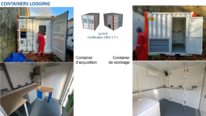
The CEEL (Center for Geophysical and Hydrodynamic Studies in Wells) serves as a national academic center and houses national and international equipment for geophysics in shallow wells. The platform is currently equipped with four field vehicles, four winches with four-conductor cables ranging from 200 to 1200 meters in length, and approximately 25 geophysical and hydrodynamic measurement probes for wells.

The presence of data acquisition systems for geophysical measurements in boreholes, as well as boreholes reaching depths of up to 100 m, offers a unique opportunity to present this methodology in a practical setting. Since 2001, this site has been used to train students from the University of Montpellier 2, the EOPG engineering school in Strasbourg (2003-), the University of Pau and the Adour Region (2004-present), ETH Zurich in Switzerland (2007-present), and IGAL. In addition to the training courses conducted at CEEL, data from instrumented sites monitored by the TMP team at the Geosciences Montpellier laboratory serve as the basis for teaching. As an example, within the framework of the “Resources, Fluids and Reservoirs” course taught in the third year of the GBE program (Geosciences track at the University of Montpellier), a practical session was established based on the study of sediment cores from the Maguelone site (Hérault). The objectives of this practical session are to familiarize students with the observation and description of sedimentary records in cores, and the recognition of typical sedimentary facies (marine, fluvial, continental, lagoonal, lacustrine) in order to reconstruct the history of sedimentation by addressing the concepts of scale and eustatic variation, and to place this history within a broader regional geological context. It also involves combining these observations with field geophysical and hydrological data to reconstruct the architecture and current functioning of an aquifer in a coastal environment.
CEEL also offers training courses within the framework of European projects such as ITN Medgate (training held in November 2013) or Trust (http://cordis.europa.eu/project/rcn/106264_en.html) within which a school on CO2 storage was organized in October 2015.
Boreholes and core samples (calibration baseline)
Four boreholes, spaced no more than 15 m apart and less than 100 m deep, were drilled between 2001 and 2006. LAV-1, -2, and -3, the deepest, are aligned along a north-south axis.
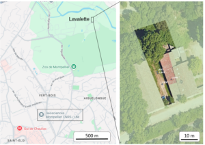
These boreholes each penetrate approximately 12 meters of Quaternary deposits originating from the Lez River, located about 100 meters away, followed by Valanginian marly limestones (143 Ma), cored in well VAL-1. The water table appears stable at a depth of 5 meters. The loose sediments encountered in the upper part of the boreholes are isolated using cemented PVC casing. The deepest boreholes are opened from a depth of 12 meters for well logging or experimentation.
Calibrations and Applications
The CEEL (Center for Experimental and Environmental Engineering) serves as a national center in the academic field and is particularly focused on developing calibration tools for the various probes deployed in boreholes, notably within the framework of European projects or industrial contracts.
The potential of this method must be combined with a much more rigorous metrological approach than those currently implemented at shallow depths in this field, especially compared to more traditional laboratory methods. The detailed analysis of the Lavalette core boreholes provides the necessary calibration basis for the rigor required in this field.
The CEEL platform enables and offers the development of complementary geophysical methods and tools for studying the first few hundred meters below the surface (or “subsurface”).
This activity relies on the resources specific to this discipline, housed at the CEEL facilities, and on the mechanical and electronics workshops of GÉOSCIENCES Montpellier.
This setup has led to the development of new tools such as:

MuSET est un outil qui possède une électrode non polarisable ‘‘Petiau’’ dans sa partie supérieure et un ensemble de capteurs hydrochimiques traditionnels à la base avec l’Idronaut (Pezard et al., 2009). Cette sonde mesure simultanément de nombreux paramètres physicochimiques du fluide en forage (p, T, Cw, pH, Eh) ainsi que le potentiel spontané, avec une grande précision.
Scientific manager :
Johanna LOFI
E-mail : johanna.lofi [at] umontpellier.fr
Technical manager :
Gilles HENRY
E-mail : gilles.henry [at] umontpellier.fr
Philippe PEZARD
E-mail : philippe.pezard [at] umontpellier.fr
Philippe GOUZE
E-mail : philippe.gouze [at] umontpellier.fr
Laurent BRUN
E-mail : laurent.brun [at] umontpellier.fr
Muriel GEERAERT
E-mail : muriel.geeraert [at] umontpellier.fr
Gérard LODS
E-mail : gerard.lods [at] umontpellier.fr
Fadl RAAD
E-mail : fadl.raad [at] umontpellier.fr
Erwan LE BER
Courriel : erwan.le-ber [at] umontpellier.fr
Simon BARRY
Courriel : simon.barry [at] umontpellier.fr
Building 22
Campus Triolet
Address :
GEOSCIENCES MONTPELLIER
Université de Montpellier – CC 60
Place Eugène Bataillon
34095 MONTPELLIER Cedex 5
FRANCE
Vehicles access :
475 Rue du Truel
34090 MONTPELLIER
Géosciences Montpellier
Université de Montpellier
Campus triolet cc060
Place eugène bataillon
34095 montpellier cedex05
FRANCE
Where to find us